
2 | Origin and Evolution of British Provinces
- May 6
- 17 min read
Updated: May 23
By Gaurav Kalyani and Shivakumar Jolad
Published on: 7 May 2026
The origin of British provinces follows the trajectory of evolution of small trading settlements to a vast, complex administrative structure, a gradual process of transition.
In this article, we trace the origins and evolution of British provinces, looking closely at how they developed from the trading outposts of the East India Company to the sophisticated bureaucratic machinery of the late colonial state.
Pre-colonial context
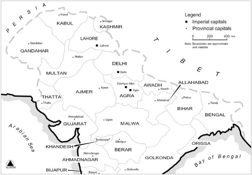
Before the British arrived, the Mughal empire dominated much of the Indian subcontinent until the early eighteenth century. It possessed a sophisticated administrative system organized around the mansabdari structure. Under this structure, the empire was divided into provinces (subahs), further subdivided into districts (sarkars), and then into smaller units (parganas).
This system was introduced by Akbar between 1572 to 1580. He originally divided the empire into 12 provinces: Kabul, Lahore, Multan, Delhi, Agra, Avadh, Illahabad, Bihar, Bengal, Malwa, Ajmer, and Gujarat (Niaz, Wikipedia).
The governance of Subah was characterized by division of power and at the head of the hierarchy was Subedar, who served as the governor of the province. The emperor frequently transferred Subedars to ensure that they did not develop ownership over that land.
Under Jehangir the number of Subahs increased to 17, under Shah Jahan 22 and reached its peak of 22 under Aurangzeb, when the Mughal empire was largest at its territorial extent. Under Aurangzeb, this system faced increasing strain due to incessant warfare in the Deccan. The fiscal pressure due to this war led towards more predatory tax collection methods which ultimately contributed to the fragmentation of the Subah system after his death in 1707.
This system was characterized by several aspects that would influence British administration later (Dodwell, 1932).
However, it suffered from some key flaws - there was no clear separation between military and civil functions, officials served at the emperor's pleasure, with no security of tenure or defined career progression and the system of jagir meant officials were frequently transferred, preventing them from developing deep local knowledge. Most importantly, there was no institutional framework that could survive even though the central authority became weak (Niaz, 2019).
Table 1: Mughal Administrative Hierarchy
Level | Title | Key Functions |
Imperial | Badshah (Emperor) | Supreme authority, military commander, ultimate judicial authority |
Provincial | Subedar (Governor) | Revenue collection, military command, administration |
Divisional | Faujdar/Shiqdar | Law and order, military policing, revenue support |
District | Amil/Aml-guzar | Land revenue collection, local administration, dispute resolution |
Village | Zamindar/Headman | Revenue collection coordination, local policing, community governance |
Source: Mathew, 2020
From factories to provinces
The British presence in India began not with territorial ambition but with trade and commerce. The East India Company established its first factories at Surat (1613), Madras (1640), and Bombay (1668). These trading posts were governed by a President and Council, with authority derived from royal charters rather than territorial conquest. The Company's transformation from trader to territorial power began with the Battle of Plassey (1757) and the grant of the Diwani of Bengal (1765) (Baden-Powell, 1892).
Suddenly, the Company found itself responsible for the revenue administration of Bengal, Bihar, and Orissa. These territories combined were essentially larger than Britain itself and therefore the existing administrative structures were inadequate for the new rulers (Baden-Powell, 1892).

As these factories grew into towns, they came to be known as Presidency Towns, which evolved to become the first three presidencies: Bengal, Madras and Bombay. The Regulating Act of 1773 marked the first parliamentary intervention in Indian affairs and established the foundations of a British Indian state (Baden-Powell, 1892).

These three historical Presidencies were known as ‘Regulation Provinces’, meaning they were governed by a strict code of "Regulations" enacted by their respective Governors and Councils before a general Legislative Council was formed in 1834. It also established a Supreme Court and required that important decisions be made by majority vote in council (Baden-Powell, 1892).
Conquered or ceded territories were initially attached to the Presidency whose forces subdued them. The Charter Act of 1833 formally created the Government of India, changing the head's title to the Governor-General of India, based in Calcutta, with authority over these three presidencies. This period was marked by the Presidencies becoming too large for single-point management (Baden-Powell, 1892). In the following section, we look at the history of these three presidencies more closely.
Bengal

The British presence in Bengal began with Fort William (1698), which was established as a factory for trading purposes. Following the military victory at the Battle of Plassey in 1757 and the Battle of Buxar in 1764, the East India Company emerged as a territorial power. In 1765, the Timurid (Mughal) Emperor granted the Diwani (the right to collect revenue) for Bengal, Bihar, and Orissa to the Company, initiating a period of dual government until 1770 (Dodwell, 1932).
The Regulating Act of 1773 formally created the Presidency of Fort William in Bengal. Warren Hastings became the first Governor-General, and he centralized administration in Calcutta, appointing the first British Collectors to oversee revenue. Then under Lord Cornwallis, the Cornwallis Code of 1793 and the Permanent Settlement institutionalized the administration, dividing Bengal into 16 very large districts (Baden-Powell, 1892; Dodwell, 1932).
The Presidency rapidly expanded when Benares Province was formally annexed in 1800, Large tracts in the north-west (modern-day Uttar Pradesh) were added and Modern-day Cuttack, Balasore, and Puri were ceded from the Marathas in 1803. Burmese cessions of Assam, Arakan, and Tenasserim (1826) were incorporated later (Baden-Powell, 1892; Dodwell, 1932).
By the 1830s, the Presidency had grown too vast for effective centralized control. In 1836, the "Upper Provinces" were separated to form the North-Western Provinces under a Lieutenant-Governor, though they remained technically part of the Bengal Presidency. In 1854, the "Lower Provinces" (Bengal, Bihar, Orissa, and Assam) were placed under their own Lieutenant-Governor to relieve the Governor-General of local duties (Baden-Powell, 1892; Dodwell, 1932).

Following the 1857 Uprising, the Crown assumed direct rule and the Presidency evolved into a more professionalized bureaucracy. Assam was separated in 1874 to become a Chief Commissionership (Baden-Powell, 1892; Dodwell, 1932).
By 1905, the population of the Lower Provinces had reached nearly 75 million, leading the British government to decide for the Partition of Bengal. In 1905, Lord Curzon divided the territory into Western Bengal, Bihar, and Orissa and a new province of Eastern Bengal and Assam. Although this move was intended to ease the administrative burdens, there was also a motive to weaken the political opposition in Calcutta (Kavanaugh, 2017).

In 1912, there was an intense public outcry and protests against the partition, leading to the reversal of the decision. Following that, Bihar and Orissa were separated as a distinct province, and Bengal was reunited and elevated to a Governor-in-Council status. By the early 20th century, the Presidency had transformed from a loosely governed collection of large districts into a complex network of 48 districts and 134 subdivisions (Kavanaugh, 2017).
Bombay
The British established a factory in Surat in 1613, marking the beginning of their presence in western India. Initially the island of Bombay was the first British possession, as it was ceded by the Portuguese to King Charles II in 1661 as part of the marriage dowry and it was subsequently granted to East India Company in 1669 (Baden-Powell, 1892; Dodwell, 1932).

As more dependent towns and factories grew around Bombay, it became known as the Presidency Town. For much of the 19th century, the Presidency was confined to small areas of Bombay Island, Bankot and Surat. These sites were initially governed by Presidential Boards which were the tenets of the Mughal Emperor (Baden-Powell, 1892; Dodwell, 1932).
The Presidency’s territories started to grow through successive wars, treaties and annexations. Between 1800 and 1817, Surat, Bharuch, Kaira, and Ahmedabad were acquired from the Nawab of Surat and the Gaekwar of Baroda. The end of the third Anglo-Maratha War in 1818, brought in the Peshwa's vast territories, including the Deccan, Khandesh, and Dharwar. Under the Doctrine of Lapse, territories like Satara and Bijapur were added following the death of rulers without heirs in 1848 (Baden-Powell, 1892; Dodwell, 1932).
The Panch Mahals were leased from Sindhia in 1853 and formally transferred to Bombay in 1861. Distant territories like military station at Aden and Sindh province were attached to the Bombay presidency in 1839 and 1843 respectively, due to their geographical proximity to the presidency. The North Kanara district was transferred from Madras to Bombay in 1862 (Baden-Powell, 1892; Dodwell, 1932).
The Regulating Act of 1773 formally placed the government of the Bombay Presidency under a Governor and Council, though it was subordinate to the Governor-General of Bengal regarding war and peace. Bombay was a Regulation Province, meaning it was governed by a strict code of regulations enacted by its Governor and Council (Baden-Powell, 1892; Dodwell, 1932).

Under Governor Elphinstone, the government consolidated years of legislation into a revised code that served as the Presidency's legal framework. Bombay primarily utilized the Ryotwari system, where the government dealt directly with individual cultivators and collected tax revenue directly from them (Baden-Powell, 1892; Dodwell, 1932).
The district was the primary administrative unit, headed by a Collector. The districts were divided into tahsils (revenue subdivisions) managed by mamlatdars (or tahsildars). Initially, the British maintained the village watch system, holding the village Patil (headman) responsible for order. Justice was historically divided between the Supreme Court (for Bombay Island) and Sadr Adalats (for up-country districts), which were later unified in 1865 to form the Bombay High Court (Baden-Powell, 1892; Dodwell, 1932).


By the mid-19th century, the Presidency had evolved from a single island into a compact and highly organized administrative unit. Under Crown rule after 1858, the Presidency transformed into a centralized bureaucratic state with specialized departments for Public Works (1854), Forests (1860), and Education (1855). Following the 1861 Councils Act, legislative councils were established, which eventually incorporated elected Indian members to represent municipalities and district boards (Baden-Powell, 1892; Dodwell, 1932).
The Government of India Act of 1919 recognized Bombay as a semi-autonomous federating unit with independent taxation rights and diarchy was implemented in Bombay along with eight other Provinces. The 1935 Act gave further recognition and separated Sindh into a distinct Province (Baden-Powell, 1892; Dodwell, 1932).
Madras

The British East India Company established Fort St. George in 1640 for the purpose of trade, which later evolved into the city of Madras. Similar to Bombay, it became a Presidency town when the settlement grew and established out-station dependencies.
The Presidency reached its vast extent of approximately 140,000 square miles through the attachment of territories subdued by its forces or acquired through treaties. Territories were acquired from the Sultanate of Mysore following the Mysore Wars (1792-1799). In 1800, Nizam of Hyderabad ceded some districts in the Rayalseema area and in 1801, Nawab of Carnatic ceded some districts from the Tamil Nadu region, including Arcot, Thirunaveli, and Madurai etc. (Baden-Powell, 1892; Dodwell, 1932).
The Treaty with Nizam Ali Khan (Asaf Jha- II) of Hyderabad ceded Northern Circars (Northern Coastal districts of Andhra Pradesh) to the Company. The Company agreed to hold the Northern Circars from the Nizam for an annual payment of nine lakhs or to provide troops. It also included a defensive alliance, particularly against Hyder Ali of Mysore. This treaty marked the formal British acquisition of these coastal territories. In 1788, reaffirmation of treaty with Nizam led to the Guntur Circar, which had been under the Nizam's control (or his brother's), finally coming under the direct administration of the East India Company as per the terms of the 1768 treaty (Niaz).
Treaty of Seringapatam concluded the Third Anglo-Mysore War in 1792. Tipu Sultan was forced to cede about half of his territories (which were divided among the British, Nizam, and Marathas), pay a large war indemnity of 330 lakhs of rupees. The districts of Salem, Coimbatore, Malabar, Kanara, some areas of Madurai were ceded to the East India Company during this treaty (Baden-Powell, 1892; Dodwell, 1932).
The Raja of Tanjore was forced to sign a subsidiary treaty with EIC in 1799, by which he effectively surrendered the entire administration of his kingdom to the East India Company in return for an annual pension and the retention of his title and certain privileges. Following Tipu’s death in Fourth Anglo-Mysore war in 1799 and subsidiary treaty with Hyderabad, Anantapur, Bellary, and Cuddapah districts came under the Company’s control (Niaz, Baden-Powell).
Karnool was annexed in 1839, following a conflict with Nawab of Karnool and was initially administered as a non-regulation province. Finally in 1862, North Karnataka district was transferred from Madras to the Bombay Presidency (Baden-Powell, 1892; Dodwell, 1932).

The Regulating Act of 1773 placed the Madras Presidency under a certain degree of control of the Governor-General of Bengal (Baden-Powell, 1892; Dodwell, 1932). The Regulating Act of 1773 placed the Madras Presidency under a certain degree of control of the Governor-General of Bengal (Baden-Powell, 1892; Dodwell, 1932). The India Act of 1793, twenty years later, the Madras Presidency was formally vested in the Governor with 3 Councillors.
The Charter Act of 1833 withdrew the Presidency’s independent power to legislate and centralized all authority in the Governor-General of India in Council to ensure uniform governance (Baden-Powell, 1892; Dodwell, 1932).
Inspired by Thomas Munro, the Presidency introduced reforms in 1816 that transferred the control of the police and magisterial duties from the district judge to the Collector, establishing Collector as the primary authority managing both revenue and order. Unlike the "Permanent Settlement" of Bengal, Madras evolved a Ryotwari system, where the government entered into revenue settlements directly with individual cultivators (ryots) (Baden-Powell, 1892; Dodwell, 1932).
Following the assumption of rule by the Crown in 1858, the Presidency transitioned into a modern bureaucratic state. Specialized provincial departments were formed for Public Works (1858), Forests (1856), and Police (1859) and The Local Fund Act of 1871 and the Local Boards Act of 1884 introduced elective boards to manage roads, education, and medical relief. After the passing of the Government of India Act of 1919, Madras was recognized as a semi-autonomous federating unit with its own independent taxation and revenue rights (Baden-Powell, 1892; Dodwell, 1932).

Formation of other Provinces
As British territory expanded, it became impossible to manage all new acquisitions as simple extensions of the historical presidencies.
North-West Province (NWP) and United Province: British acquired regions of Benares in 1775 which were ceded by Nawab of Oudh. In 1801, they significantly expanded this territory through the acquisition of further ceded districts from Nawab of Oudh. This expansion continued in 1803 with the addition of conquered districts taken by Lord Lake from Scindia and others (Baden-Powell, 1892; Dodwell, 1932).
Between 1803 to 1817 the region was further consolidated with the addition of conquered Bundelkhand regions. Following the Nepal war in 1815, Dehradun district was also added to the province. Bengal's large additions in the north-west led to the creation of the Presidency of Agra in 1834, which was replaced in 1836 by the North-Western Provinces under a Lieutenant-Governor (Baden-Powell, 1892; Dodwell, 1932).
The final major addition was the annexation of Oudh in 1856, by the Nawab. This region added 12 major districts and was initially placed under a separate chief commissioner but was later amalgamated with the NWP in 1877 (Baden-Powell, 1892; Dodwell, 1932). The following table illustrates the ceded districts that were added to the NWP between 1801 to 1856 and their corresponding contemporary districts.

In 1902, the North-West Provinces were reorganized and renamed to United Provinces of Agra and Oudh or simply United Provinces. Following the Government of India Act of 1919, the United Provinces was raised to the status of a province governed by a Governor in Council, placing it on the same administrative footing as the older Presidencies like Madras and Bombay. By the early 20th century, the United Provinces had become a major constituent unit of the British Indian federation, possessing its own independent taxation and revenue rights (Baden-Powell, 1892; Dodwell, 1932).

Punjab and North-West Frontier Province: The British rule of Punjab began with the acquisition of the Delhi region in 1803 after the second Anglo-Marath war. While initially under the control of NWP, Delhi along with districts of Gurgaon, Hisar and Karnal were formed as the dependencies of south Punjab. The northern reaches of Punjab were expanded with the annexation of Shimla in 1815 as per the Sugauli Treaty after the First Anglo-Nepalese War (Baden-Powell, 1892; Dodwell, 1932).
Between 1845 and 1846, following the First Anglo-Sikh War and the subsequent Treaties of Lahore and Bhairowal, the British annexed significant Sikh territories including districts of Ambala, Firozpur, Hoshiyarpur, Jalandhar, Kangra, and Ludhiana (Baden-Powell, 1892; Dodwell, 1932).
Following the First Anglo-Sikh War (1845), the Lahore Durbar was forced to sign this treaty. It involved the cession of the Jullundur Doab, payment of a large indemnity (part of which was met by selling Kashmir to Gulab Singh), reduction of the Sikh army, and the stationing of a British Resident with significant powers in Lahore. After the Second Anglo-Sikh War in 1849, Lord Dalhousie annexed the entire Punjab, ending the Sikh kingdom. Maharaja Dalip Singh was deposed and pensioned off. This marks the completion of the British dominion up to the natural frontiers of India in the north-west (Baden-Powell, 1892; Dodwell, 1932).
Following the 1857 Uprising, the Delhi territory was transferred from the NWP to the Punjab because communication from the NWP had been cut off during the mutiny. The Punjab province had Ludhiana, Ambala, Jalandhar, Kangra, Firozpur, Lahore, Amritsar, Gurdaspur, Gujranwala, Sialkot, Rawalpindi, Jhelum, Shahpur, Multan, Montgomery, Muzaffargarh and Delhi territory (Baden-Powell, 1892; Dodwell, 1932).
Punjab (which included NWFP initially) was initially managed by a Board of Administration. In 1853, a Chief Commissioner replaced the Board to streamline the executive functions. Later It became a separate Lieutenant-Governorship in 1859 (Baden-Powell, 1892; Dodwell, 1932).


Under Viceroy Lord Curzon, North-West Frontier Province (NWFP) was separated from Punjab province in 1901, driven by the need for more efficient management of furthest northern frontier regions and tribal areas. It was a political strategy to isolate frontier districts from standard legal and constitutional procedures while maintaining special administrative measures such as Frontier Crimes Regulation, a draconian law to govern these regions. The districts that went to NWFP were Peshawar, Hazara, Kohat, Bannu and Dera Ismail Khan (Baden-Powell, 1892; Dodwell, 1932).

Central Province: The Central province was formed through amalgamation of several territories acquired from the Maratha rulers, primarily through military conquest and doctrine of lapse. The territories of Nabha and Sagar were added first, which were ceded by the Peshwa and Scindia in 1818, following the third Anglo-Maratha war. Initially these areas were attached to the North West Province (Baden-Powell, 1892; Dodwell, 1932).
The Sambhalpur district was added in 1849 through doctrine of lapse, followed by addition of Nagpur territories after the last Bhosale ruler died in 1854. Finally in 1861, these disparate territories were consolidated to form the Central Province, put under the Chief Commissionership (Baden-Powell, 1892; Dodwell, 1932).
In 1853, following a new treaty with the Nizam, Berar came under British control (although nominally under the Nizam) . Nizam of Hyderabad ceded Sironcha, Nimar and Berar districts in 1860 to 1863, They became "Hyderabad Assigned Districts”. In 1902, Nawab Mir Mahbub Ali Khan leased Berar permanently to the British against an annual payment of 25 lakhs Rupees. In 1903, under Lord Curzon, Berat was attached to the Central Provinces.
Following the Government of India Act of 1919, Central Province was raised to the status of autonomous province governed under Governor in Council, granting it substantial autonomy in administrative and financial matters (Baden-Powell, 1892; Dodwell, 1932).


Assam and North-East Frontier Tracts (NEFT): The British started to administer Assam when they obtained Goalpara and Sylhet regions as part of the Diwani grant in 1765. Following the first Burmese War in 1824, they expanded the territories with the addition of districts acquired from Burma after the Treaty of Yandabo in 1826.
Due to the distinct conditions and relations with the local tribal population, Assam was governed under a non-regulation system (Baden-Powell, 1892; Vaghaiwalla, 1951). Between 1830 to 1835, the British brought additional Hill districts such as Cachar Hills, Khasi and Jaintia Hills under control.
As the Bengal Presidency grew increasingly over-burdened, Assam was formally separated from it in 1874 and placed under Chief Commissioner. The British continued the conquest of Hills region, defeating Garo tribes in 1872-73, leading to the addition of Garo Hills district. Following the Chin-Lushai expedition in 1889, the north and south Lushai Hills (modern day Mizoram) were brought under British authority (Baden-Powell, 1892; Vaghaiwalla, 1951).
During the partition of Bengal, Assam was briefly combined with eastern districts of Bengal to form the province of Eastern Bengal, however it was short lived. After the reversal of the partition, Assam was re-established as a separate province.
In 1914, after the Abor Expedition following the murder of British officials, the North-East Frontier District, later named North-East Frontier Tract (NEFT) was formed as an administrative unit separate from Lakhimpur to maintain closer relations with the hill tribes. The framework for this region was established during the Simla Conference of 1914, when the McMahon line was drawn to define the boundary between India and Tibet (Baden-Powell, 1892; Vaghaiwalla, 1951).
It was initially divided into two sections - Central and Eastern Sections and Western Section. The Central and Eastern sections were later renamed as Sadiya Frontier Tract and Western Section to Balipara Frontier Tract in 1914. A newly constituted district was formed in 1942 from parts of Sadiya district, parts of Lakhmipur and Naga Tribal areas, which was named as Tirap Frontier Tract (Baden-Powell, 1892; Vaghaiwalla, 1951).


Coorg: Coorg was a little province comprising hilly country, situated along the top of the Western Ghats ranges, with only a small tracts in north and east lying below the Ghats. It was formally annexed by the British in 1834 due to continued mis-governance of its local ruler. Unlike other territories annexed during this period, Coorg was not attached to any of the three major presidencies (Bengal, Bombay, Madras) and remained separate (Baden-Powell, 1892; Dodwell, 1932).
Because the people and the land tenures of Coorg were considered unique and peculiar, the British administration decided to manage it separately rather than merging it with any larger province. Its status was formalized under the Act of 1854. This legislation empowered the Governor-General to take such territories under his direct authority and place it under the administration of Chief Commissioner. The Resident of Mysore served as the ex officio Chief Commissioner of Coorg (Baden-Powell, 1892; Dodwell, 1932).
Under the Act XIV of 1874, Coorg was designated as a scheduled district. This meant that only specific legislative enactments were in force, allowing for a more simpler form of rule, suitable for its unique conditions. In the later period, Coorg province’s boundaries were slightly altered when 2 talukas were separated from it and were added to South Kanara district in Madras Presidency. Coorg remained a Chief Commissioner’s province in the early 20th century (Baden-Powell, 1892; Dodwell, 1932).
Andaman & Nicobar Islands: The British set up a penal colony at Port Blair on Andaman Islands in 1858. Andaman islands was constituted as a Chief Commissionership in 1872, placing them among few ‘unattached’ territories that were not part of any other presidencies or provinces. The governance structure was legally formalized under the Act of 1854 (Baden-Powell, 1892).
By the early 20th century, Andaman and Nicobar islands were categorized as distinct territories that were not part of any major province. The Chief Commissioner at Port Blair acted as the local administrator, carrying out the orders of the British government of India. In the post-independence period, the islands are managed as Union Territories, under the direct control of the Union government.
Provincial Administration
Following the 1857 rebellion, the Crown assumed direct control via the Government of India Act of 1858. This period saw the presidencies evolve into specialized administrations governed by centralized departments such as Forests, Police, and Education. The Indian Councils Act of 1861 established legislative councils in the provinces and formalized the distinction between the three Presidencies (governed by Governors) and other provinces (governed by Lieutenant-Governors). The Act also empowered the Governor-General to create new provinces and appoint Lieutenant-Governors for them (Niaz, 2019).
The provinces attached to the three Presidencies were governed by elaborate regulations enacted by the Presidency governments. Territories not attached to any Presidency were governed under a non-regulation system. These territories were Punjab, Oudh, Central Province, Assam, British Burma and Coorg. These provinces were not subject to the existing regulations, and their administration was based on rules issued by the Governor-General in his executive capacity (Niaz, 2019).
The distinction between regulation and non-regulation provinces gradually diminished over time. By the late nineteenth century, many non-regulation provinces had been brought under regular legislation (Niaz, 2019).
The legacy of the British provinces is not simply institutional. The provinces became the basis for regional identities, political organization, and economic development. The British provincial system, for all its flaws, provided a framework for governance that was remarkably durable. It survived the transition to independence and continues to influence the administrative structures of India today (Niaz, 2019).

Legacy of provincial systems
By gradually replacing the fragmented Mughal Subah system, the British evolved a sophisticated and complex system of governance administered through provinces. This provincial system left a lasting legacy on the administration of the post-independence states, forming the basis of regional identity and political organization.
Sources:
Baden-Powell, B. H. (n.d.). The Land Systems of British India (Vol. 1). Oxford University Press. (Original work published 1892)
Dodwell, H. H. (Ed.). (1932). The Indian Empire: Volume VI. Cambridge University Press.
Kavanaugh, A. (2017). 'Our Rule in India rests wholly on ourselves’—The District Officer in Bengal 1850 – 1905 [PhD Thesis]. King’s College London.
Mathew, C. K. (2020). The Historical Evolution of the District Officer: From Early Days to 1947. Azim Premji University
Niaz, I. (2019). The State During the British Raj—Imperial Governance in South Asia 1700-1947. Oxford University Press.
Vaghaiwalla, R. B. (1951). North-Eastern Frontier Agency: District Census Handbook. Census, 1951 - Assam. Census of India.


Comments