
4 | Mapping of district changes in early decades 1951-1971
- Aug 2, 2025
- 8 min read
Updated: Aug 23, 2025

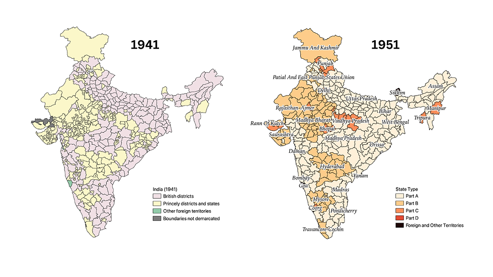
In 1951, India consolidated provinces and princely states into 310 districts across 29 states (classified as Part A, B, C, and D). The map of India in 1951 reflected a nation rapidly consolidating its territory after independence. The redrawing of state boundaries continued to happen after 1951 with the linguistic reorganization of states in 1956, based on the State Reorganisation Commission’s recommendations. This laid the foundation for India’s current map.
District changes between 1951 to 1961
The creation of new districts between 1951 and 1961 reflects India's efforts to address administrative efficiency, regional integration, and the unique needs of newly formed states or territories. The Indian states were drastically reorganized, many primarily in 1956 based on linguistic reorganization of state. Many fragmented parts were consolidated into coherent units, based on language, administrative convenience, economic feasibility, historical and cultural factors. State reorganization also led to a more coherent administrative set up across India (with exceptions for tribal areas and North Eastern states as outlined in the Constitution: in the Article 244-fifth and sixth schedule and Article 370 and 371).
The stage reorganization also led to consolidation of many districts and formation of new districts. The number of districts increased from 310 to 340. This also included the addition of Portuguese and French Territories. Jammu and Kashmir, which did not have British style districts, was brought under a common administrative set up with 9 districts. Kerala did substantial reorganization of the districts, craving out 5 new districts. Three new districts were created in the region of present Uttarakhand.
The Census publication ‘A Historical Perspective of Evolution of Districts and States in India. Registrar General of India’ (Singh et al, 2004), records the comprehensive changes in the administrative reorganization between 1951-61. They are summarized as follows:
Assam State: Lost a border strip of Kamrup district to Bhutan in 1951.
NEFA (North East Frontier Agency, now Arunachal Pradesh) reorganized into five districts: Kameng, Subansiri, Siang, Lohit, and Tirap Frontier Divisions, and declared a separate administrative unit out of Assam. Kameng Frontier Division and Subansiri Frontier Division were carved out of the Balipara Frontier Tract,
Nagaland (1957): Mokokchung was created from Tuensang, highlighting the focus on providing administrative representation to the unique tribal identities in the newly created state.
Further reduced by the creation of Naga Hills-Tuensang Area in 1957 (Act of 1957). Kohima and Mokokchung sub-divisions of old Naga Hills became separate districts. Tuensang became part of this new unit. Total three districts: Kohima, Mokokchung, and Tuensang.
The number of districts (11) in Assam remained unchanged, but Lushai Hills district changed to Mizo Hills.
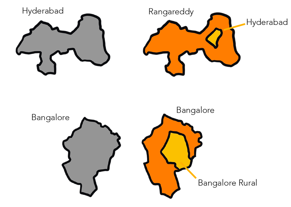
Andhra Pradesh: Andhra State came into existence in 1953 from the northern part of old Madras state, including Srikakulam, Visakhapatnam, East Godavari, West Godavari, Krishna, Guntur, Nellore, Kurnool, Anantapur, Cuddapah, and Chittoor. In 1956, eight districts of former Hyderabad state (Hyderabad, Medak, Nizamabad, Karimnagar, Warangal (except some taluks), Nalgonda, Mahbubnagar, Adilabad) were added to Andhra Pradesh. New district Khammam carved out from Warangal and other adjoining districts. Boundaries of Chittoor (Andhra Pradesh) and Salem, Chingleput, North Arcot (Madras) were adjusted. Total 20 districts in Andhra Pradesh in 1961.
Bihar State: Lost Purulia district and a portion of Purnea district to West Bengal state as per Bihar and West Bengal Transfer of Territories Act, 1956. Districts reduced from 18 to 17.
Bombay State (Pre-Maharashtra/Gujarat): Formed in 1956 by inter-state transfers. Lost four districts (Dharwar, Kanara, Bijapur, Belgaum) to Mysore state and Abu Road taluk (Banaskantha) to Rajasthan.
Gained areas from Hyderabad (Aurangabad, Parbhani, Bhir, Osmanabad, Nanded, parts of Bidar, Adilabad) and Madhya Pradesh (Buldhana, Akola, Amaravati, Yeotmal, Wardha, Nagpur, Bhandara, Chanda). Erstwhile states of Saurashtra and Kutch merged and made two separate districts.
Gujarat and Maharashtra: Bombay Reorganisation Act, 1960 bifurcated the former Bombay state into Gujarat (17 districts: Jamnagar, Rajkot, Surendranagar, Bhavnagar, Junagadh, Kutch, Amreli, Banaskantha (except Abu Road), Sabarkantha, Mehsana, Ahmedabad, Kaira, Panchmahals, Baroda, Broach, Surat, Dangs, plus small areas of West Khandesh and Thana) and Maharashtra (26 other districts of former Bombay state).
Madras State: Lost almost half of its northern part to Andhra Pradesh in 1953, reducing districts from 26 to 13. In 1956, Madras lost Malabar district and Kasaragod taluk (South Kanara) to the newly created Kerala state, and Kollegal taluk (Coimbatore) to Mysore state. Gained four taluks of Trivandrum (Kerala) to form new Kanyakumari district and Shencottah taluk (Quilon, Kerala) to merge with Tirunelveli district.
Mysore State: Formed in 1956 by merging portions of Bombay, Hyderabad, Madras, and whole areas of Coorg and Mysore states. Gained Belgaum, Bijapur, Dharwar, North Kanara (Bombay), Gulbarga, Raichur, Bidar (Hyderabad), parts of South Kanara, Bellary, Kollegal taluk (Coimbatore, Madras), and nine districts of former Mysore state. Total 19 districts in 1961.
West Bengal State: Gained Ex-French Territory of Chandernagore (1954 Merger Act), Purulia district, and portion of Purnea district from Bihar (1956 Transfer of Territories Act). Boundaries of Jalpaiguri and 24-Parganas affected by inter-district transfers. Total 16 districts.
Kerala State: Formed in 1956 from a big chunk of old Travancore-Cochin state. Malabar district and Kasaragod taluk (South Kanara, Madras) added. Divided into nine districts. Five new districts—Alleppey, Cannanore, Kozhikode, Palghat, and Ernakulam—were carved out from existing districts like Malabar, Kottayam, Quilon, and Trichur.
Orissa State: No change in administrative boundaries, maintained 13 districts.
Punjab State: Patiala and East Punjab States Union (PEPSU) and former Punjab area merged to form the present Punjab state. Lahul & Spiti district was formed from Kullu tahsil. Total 19 districts in 1961.
Uttar Pradesh: Unaffected by external boundary changes. Internally, three new hill districts were created: Uttar Kashi, Chamoli, and Pithoragarh, increasing districts from 51 to 54. Chamoli, Pithoragarh, and Uttarkashi were carved out from Garhwal, Almora, and Tehri Garhwal, respectively, to streamline governance in the hilly regions.
Himachal Pradesh: Bilaspur (Part C state) merged in 1954, becoming 5th district. 6th district was created in 1960 by grouping Chini tahsil and villages of Rampur tahsil (Mahasu). Total six districts in Himachal Pradesh Union territory in 1961.
Madhya Pradesh State: Formed by inclusion of major portion of old Madhya Pradesh (excluding 8 districts merged into Maharashtra), complete Madhya Bharat state (excluding one taluk to Rajasthan), Sironj sub-division (Kota, Rajasthan), and entire areas of Bhopal and Vindhya Pradesh states. New districts Damoh, Narsimhapur, and Seoni were carved out. Total 43 districts.Five new districts, including Narsimhapur, Damoh, East Nimar, West Nimar, and Seoni, were created to reorganize large districts like Hoshangabad, Sagar, and Nimar.
Rajasthan: Ajmer merged, becoming 26th district. Gained Abu Road taluk (Banaskantha, Bombay) and Sunel Tappa (Bhanpura tahsil, Mandsaur, Madhya Bharat). Excluded Sironj sub-division (Kota) to Madhya Pradesh.
Union Territories/Other Areas: Part C and Part D states/areas from 1951 were reconstituted as Union territories/other areas under the States Reorganisation Act (1956) and Tenth Amendment (1961). These included Andaman & Nicobar Islands, Dadra & Nagar Haveli, Delhi, Goa, Daman & Diu, Himachal Pradesh, Laccadive, Minicoy & Amindivi Islands, Manipur, Naga Hills-Tuensang Area, NEFA, Pondicherry, Sikkim, and Tripura.
Laccadive, Minicoy and Amindivi Islands: Constituted by joining Laccadive and Minicoy Islands (Malabar district) and Amindivi Island (South Kanara district).
Goa, Daman and Diu: Liberated from Portuguese control on Dec 19, 1961, established as a Union territory.
Dadra & Nagar Haveli: Liberated Aug 2, 1954, became uni-district Union territory Aug 11, 1961.
Pondicherry: Along with Karaikal, Mahe, Yanam, merged with Indian Union. De-facto transfer Nov 1, 1954, de-jure Aug 16, 1962. Comprised four districts in different locations.
Jammu and Kashmir (1956):Seven new districts were created: Anantnag, Baramulla, Doda, Jammu, Kathua, Ladakh, Poonch, Srinagar, and Udhampur, reflecting the need for more granular administration in a geographically and politically sensitive region after its accession to India in 1947. The districts catered to the diverse topography and population in the Kashmir Valley, Jammu, and Ladakh regions.

District changes between 1961 to 1971
Between 1961 and 1971, India witnessed the creation of several new districts across various states and Union Territories. The pattern of district creation during this decade reflects a combination of factors, including administrative reorganization, integration of former colonial territories, addressing regional and ethnic aspirations, and improving governance in remote areas.
North-Eastern Reorganization:
Assam: Reorganized, leading to two new administrative units:
Meghalaya: Declared an Autonomous state on April 2, 1970 (Assam Reorganisation Act, 1969, and North-Eastern Areas Act, 1971). Areas of Garo Hills and United Khasi & Jaintia Hills districts transferred from Assam.
Mizoram: Complete Mizo Hills district (Assam) declared Mizoram Union territory under the North-Eastern Areas Act, 1971.
Assam state left with eight districts. In 1970, Mikir Hills (now Karbi Anglong) and North Cachar Hills were created from the former United Mikir and North Cachar Hills district. Total nine districts in Assam.
Arunachal Pradesh: North East Frontier Agency (NEFA) renamed Arunachal Pradesh under the North-Eastern Areas Act, 1971. Number of districts (five) unchanged, "Frontier Division" suffix deleted.
Nagaland: Naga Hills-Tuensang Areas Union territory given statehood and renamed Nagaland under the State of Nagaland Act, 1962. Three districts in 1971. Nagaland: Phek district was created in 1973 from Kohima district to enhance administrative focus on specific Naga tribes and regions.
Manipur and Tripura: Former uni-district Union territories given statehood under the North-Eastern Areas Act, 1971, without external boundary changes. Manipur: The state underwent significant administrative restructuring in 1969, dividing the single district into five districts—Manipur Central, East, North, South, and West—to improve governance and address ethnic diversity. Tripura into three (North, South and West).
Punjab Reorganization (1966):
Haryana: Created as a new state from predominantly Hindi-speaking areas of Punjab. Districts of Hisar, Rohtak, Mahendragarh, Gurgaon, Karnal, Ambala, and Jind came under Haryana. Ambala district (parts retained in Punjab, parts merged in Haryana forming Ambala district). New Jind district was created from Narwana and Jind tahsils. Total seven districts in Haryana in 1971.
Chandigarh: A new Union territory formed under Punjab Reorganisation Act, 1966, comprising Chandigarh and Mani Majra towns and surrounding villages of Kharar tahsil. Capital for Punjab, Haryana, and Chandigarh UT.
Punjab: Size and number of districts drastically reduced. New Ropar district formed from parts of Ambala and Hoshiarpur. District boundaries of Patiala, Amritsar, Firozpur, Jullundur, Ludhiana, and Bhatinda marginally reorganized. Eleven districts remained in Punjab.
Himachal Pradesh: Given statehood in January 1971. Districts of Kangra, Simla, and Lahul & Spiti from erstwhile Punjab transferred to Himachal Pradesh. Kulu tahsil (Kangra) declared a separate district in 1966. Other tahsil-level changes in Kinnaur, Mahasu, Sirmaur, and Kangra. Total ten districts.
Jammu & Kashmir: New Rajauri district formed by bifurcating Punch district in 1967. Inter-district transfers. Total ten districts in 1971.
Andhra Pradesh: Number of districts increased from 20 to 21 with creation of Ongole district (1970) from parts of Kurnool, Guntur, and Nellore.
Gujarat State: Two new districts added: Gandhinagar (from Ahmedabad and Mehsana) in 1964 and Valsad (from southern Surat). Districts Kaira, Baroda, Dangs, Broach, Mehsana renamed Kheda, Vadodara, The Dangs, Bharuch, and Mahesana respectively. Total 19 districts.
Maharashtra State: Chanda district renamed Chandrapur. Inter-district transfers affected Nagpur and Bhandara. Total 26 districts.
Kerala: New Malappuram district created in 1969 from Kozhikode and Palghat. Minor boundary changes in Ernakulam, Kottayam, Alleppey, Quilon, Trichur. Total ten districts.
Rajasthan: Minor changes in Udaipur and Chittaurgarh district boundaries. Total 26 districts.
West Bengal: Number of districts (16) unaltered. District boundaries of Nadia, Hooghly, and Burdwan affected by inter-district changes.
Tamil Nadu: Madras state renamed Tamil Nadu (Madras State Alteration of Name Act, 1968). Salem district bifurcated to form Dharmapuri in 1965.Inter-district changes in Ramanathapuram, Madurai, Thanjavur, and Tiruchchirappalli. Total 14 districts.
Orissa State: Minor changes in Cuttack, Puri, Dhenkanal, Koraput, and Kalahandi. Total 13 districts unchanged.
Uttar Pradesh and Bihar: Minor state boundary change due to shifting Ganga and Ghaghara rivers along Ballia (UP) and Saran, Siwan (Bihar).
Mysore, Andaman & Nicobar Islands, Delhi, Laccadive, Minicoy & Amindivi Islands: Internal and external boundaries remained unchanged
Annexation of Portuguese Territories in 1961:
Dadra and Nagar Haveli: Became a Union Territory after liberation from Portuguese rule, creating a new district to integrate it administratively into India.
Daman and Diu: Both Daman and Diu were incorporated as separate districts within the Union Territory after annexation, integrating these regions into the national framework.

Reference
Government of India. (2011). Indian Administrative Atlas 1872-2011: Census of India 2011. Registrar General of India and Census Commissioner.
Singh, R. P., Banthia, J. K., & Commissioner I. O. of R.G. & C. (2004). India Administrative Atlas, 1872-2001: A Historical Perspective Of Evolution Of Districts And States In India. Registrar General of India.

I am doing some research and will be grateful if you could direct me to a list of Colonial districts and villages and their new names please