
2 | Districts in Colonial Era
- Aug 4, 2025
- 11 min read
Updated: Apr 7
Historically, the district (by whatever name it was called) was created to enhance administrative efficiency and collection of tax. All feudal empires in India, from Mauryan to Mughals (Sarkars, headed by Fauzdar) had a form of decentralised administration at the district level for collection of taxes and implementation of administrative tasks at the local level (Eames, 1988; Nayak & Kakani, 2022). The modern form of the district as an administrative unit came into being under Warren Hastings in 1772.

The Office of Collector, set up by Warren Hastings then, had judicial, executive, and revenue powers. The post of Collector was retained as a permanent feature of local administration heading the offices of Revenue Administration, Civil Judge and Magistrate combined. The same district-level model was taken forward post-independence. To this day, barring judicial duties, the Collector is held accountable for all executive and revenue-related functions and is also tasked with additional duties such as Maintaining law and order, Revenue collection, Land reforms, Planning and development, Excise duty (in some states such as MP) and the role of the District Election Officer. (Nayak & Kakani, 2022)

India's administrative divisions underwent significant evolution between 1872 and 2001, reflecting major political and social changes, particularly India's independence in 1947 and the subsequent reorganization of states. The administrative structure was periodically adjusted based on various factors including linguistic, cultural, financial, economic, and administrative viability (Chanda, 1967). The Census of India publication “India Administrative Atlas, 1872-2001: A Historical Perspective of Evolution of Districts and States in India” (Singh et al, 2004), gives a detailed description of the changes between 1872 to 2001.
Here we provide an overview of the changes decade by decade from 1872 to 1941:
Administrative Divisions in 1872
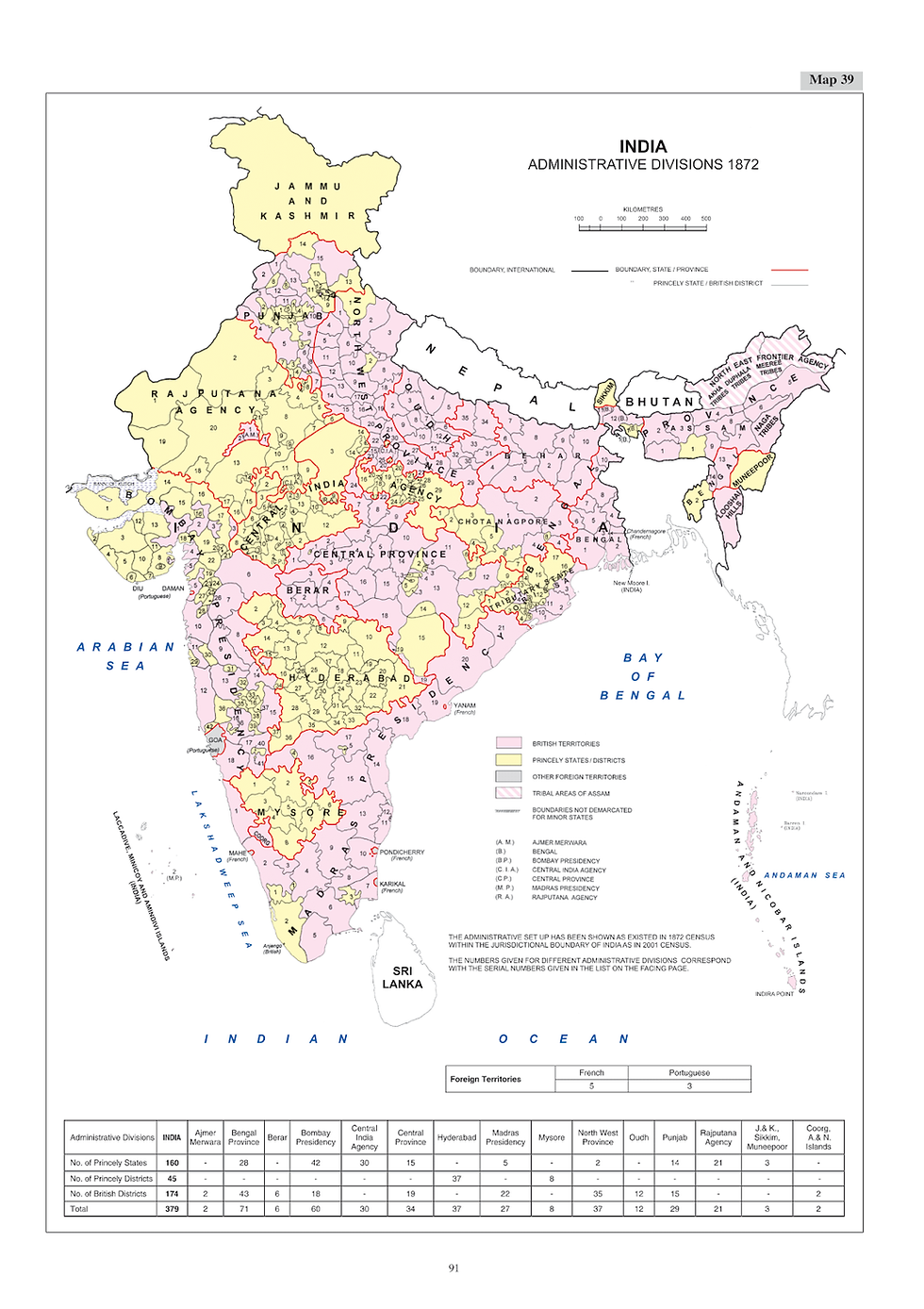
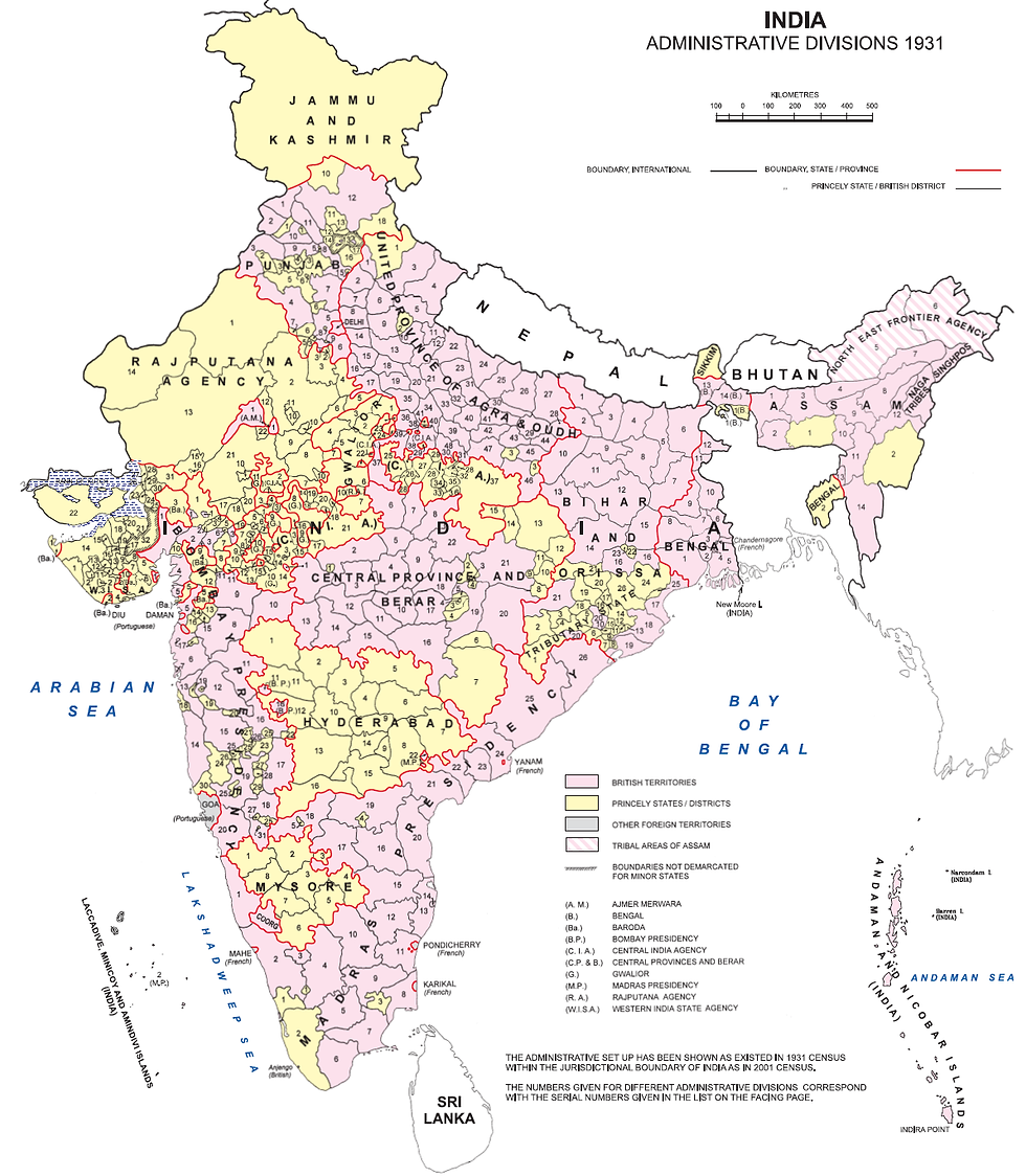
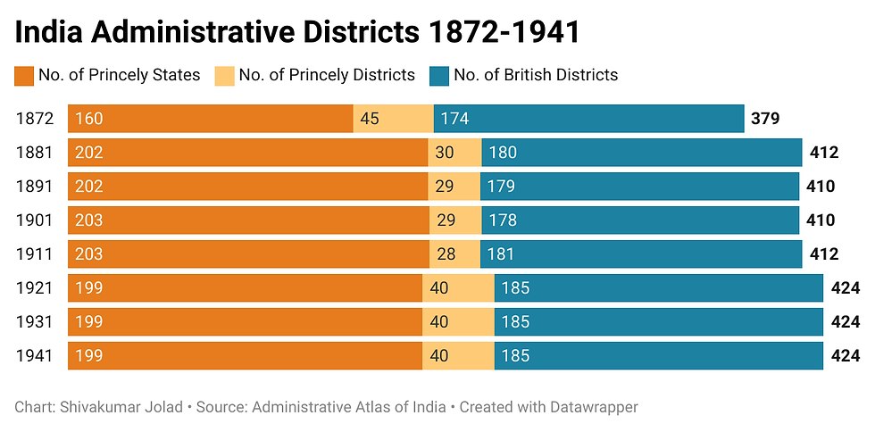
In 1872, the first Census year British India, within the modern Indian boundary (i.e. excluding areas of Pakistan, Bangladesh, Burma, and also Portuguese and French colonies in India) was divided into 379 districts. The Districts were categorized as: British Provincial Districts, Princely States, and Princely Districts, The Census documents 174 districts within the British provinces, 160 princely states or agglomeration of smaller princely states/jagirs/estates, and 45 princely districts of large states. British territories dominated district administration. Princely states maintained autonomous governance but had fewer subdivided districts.
Here is an account of the administrative divisions in 1872 as per the Administrative Atlas:
Political Control: A large part of India was under direct British control, comprising seven large provinces (Bombay, Madras and Bengal Presidencies, North-West Provinces, and Punjab under a Lieutenant Governor; Central Provinces and Oudh under Chief Commissioners) and three minor units (Coorg, Ajmer-Merwara, and Andaman & Nicobar Islands).
Princely States: A large part was also under Indian princes, whose relations with the British were governed by treaties, agreements, and sands.
Foreign Territories: Small pockets were under French and Portuguese control: Goa, Daman, and Diu were Portuguese, while Pondicherry, Karikal (Karaikal), Mahe, Yanam, and Chandernagore were French. Tribal areas of Assam were shown by pink hatching.
Divisions of India: In 1872, British India excluding current Pakistan and Bangladesh, was primarily divided into sixteen provinces : Ajmer Merwara, Bengal Province, Berar, Bombay Presidency, Central India Agency, Central Province, Hyderabad, Madras Presidency, Mysore, North West Province, Oudh, Punjab, Rajputana Agency, Muneepoor, British Burma, and Coorg. Jammu & Kashmir and Sikkim were princely territories.
Provincial Breakdowns (Examples):
Bengal Province was sub-divided into Assam, Behar, (Bihar) Bengal, Chota Nagpore, and Tributary State Orissa Commissioner's divisions. Assam had 9 British districts, Behar 10 British districts, and Bengal 14 British districts and 2 major Princely states. Chota Nagpore had Princely states like Bhokar, Korea, and Sirgoojah (Surguja), with only four British-controlled districts.
Bombay Presidency stretched over Gujarat and Bombay, comprising 18 British districts and 42 agglomerated Princely states (Gujarat and Deccan States, and Kathiawar States), accounting for about one-third of its area. Baroda was a separate Princely state.
Central Province came into being in 1862, formed by 19 British districts and 15 Princely states.
North West Province was constituted in 1836, primarily British territory with two Princely states (Gurhwal/Garwal and Rampur) and 35 British districts grouped into six divisions.
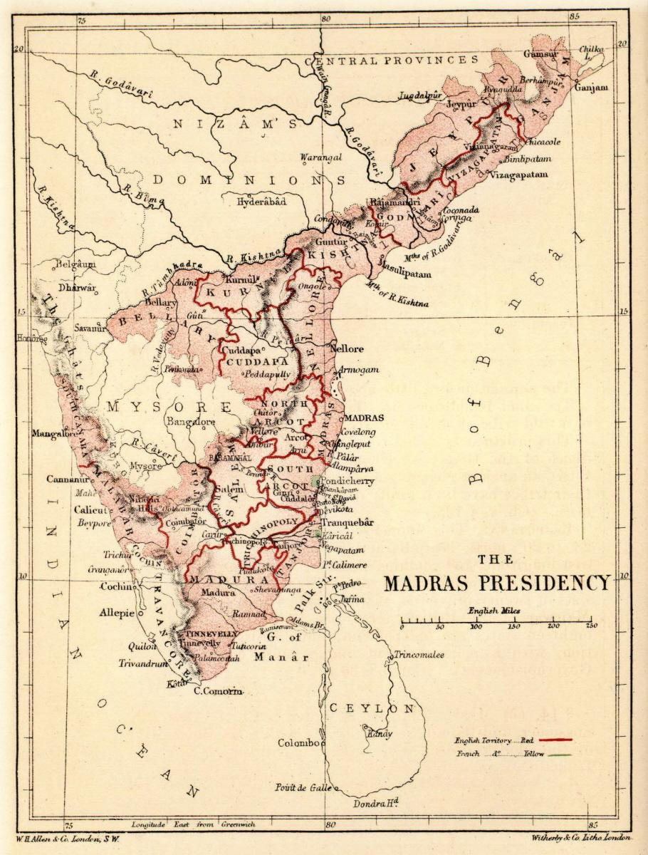
Madras Presidency had 21 British districts and 5 Princely states.
Oudh comprised 12 British districts.
Punjab had 15 British districts and 14 Princely states.
Rajputana Agency was divided into 21 Princely states.
Central India Agency had 148 Princely states, though only 30 authentic boundaries could be identified.
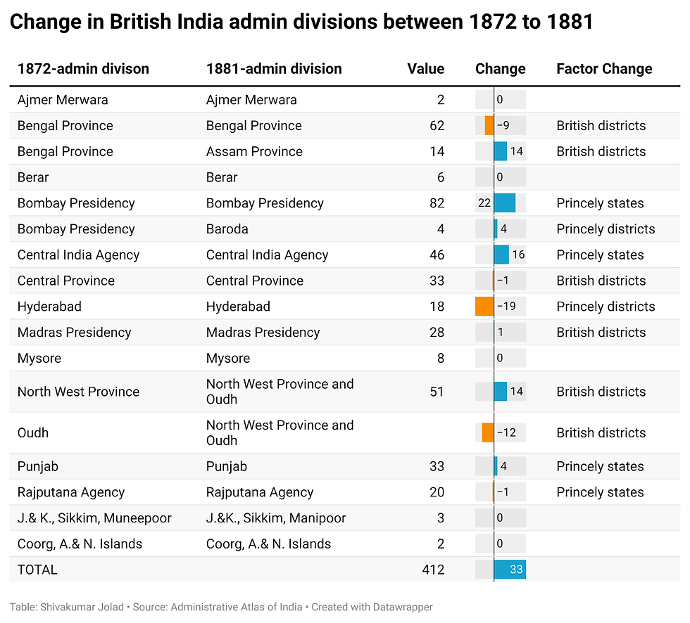
1872-1881– Provincial & District changes
Major Provincial Changes:
Assam became a separate Province from Bengal Province. Sylhet and Cachar districts were transferred to Assam in 1874. Looshai Hills and Naga Tribes territories also became part of Assam.
Oudh Province merged with the North West Province.
Baroda Princely state was formed from Bombay Presidency territories (Amreli, Kadi, Baroda, Navsari).
District and State Changes:
Bombay Presidency: The number of Princely states increased from 42 to 64. Boundary of several districts were affected by territorial transfers.
Central India Agency: Princely states increased from 30 to 46.
Central Province: Lipper Godavery amalgamated with Chanda and Godavery districts.
Madras Presidency: A part of Upper Godavery district was added to Godavery district. A new district, Anantapur, was formed from Bellary.
Hyderabad: The 37 revenue units (circars/districts) were dissolved, and the province was reconstituted into 18 Princely districts. Hyderabad was censused for the first time in 1881.
Bengal Province: Hooghly and Howrah became independent districts. Calcutta was a newly formed district. Maldah district was transferred from Bengal to Behar. Tirhoot district was bifurcated into Muzaffarpur and Darbhanga. Kharsawan became a new Princely state in Chota Nagpore. Banki was newly formed in Tributary State Orissa.
North West Province: Ballia district was newly formed from Ghazeepore (Ghazipur).
Punjab: Princely states increased from 14 to 18.
Rajputana Agency: Princely states decreased from 21 to 20.
Foreign Territories: Goa, Daman, Diu remained Portuguese; Mahe, Karikal, Pondicherry, Yanam, Chandernagore remained French.
1881-1891 - Provincial & District changes
Here is a summary of the changes
No Change in Foreign Territories.
Hyderabad Province: Princely districts decreased from 18 to 17 with the merger of Shorapur. Khamam and Nagar Karnul were renamed Warangal and Mahbubnagar, respectively.
Bombay Presidency: Panvel taluk transferred from Thana to Kolaba. Small pockets of villages transferred between Ahmednagar and Poona districts. Kaladgi was renamed Bijapur. Bijapur British district had territorial changes due to transfer of Gajendregad (Gajendragadh) jagir and Donaj village. No changes were noticed in the territorial boundaries of its 63 Princely states.
Bengal Province (Tributary State Orissa): British district Banki amalgamated with Cuttack. Angul district showed two pockets. Palamau district carved out from Lohardaga British district in Chota Nagpore.
Madras Presidency: Boundary affected by transfer of four villages from Ganjam British district to Tributary State Orissa (Bengal Province) and addition of a small part of Central Province to Godavari British district.
Punjab: Sirsa British district abolished, parts added to Ferozpur and Hissar.
Rajputana Agency: Oodeypore Princely state renamed Meywar. Jodhpore, Sirohee (Sirohi), Banswara renamed Marwar & Malani, Sirohi & Abu, and Banswara & Kushalgarh respectively.
North West Province: Minor addition due to transfer from Scindia's territory.

1891-1901 - Provincial & District Changes
No Change in Provincial Boundaries: All changes were intra-provincial.
Assam Province: Changes in territorial boundaries of Nowgong, Darrang, Lakhimpur, Sibsagar, Naga Hills, Khasi & Jaintia Hills, Cachar, and Sylhet British districts. Khasi Princely state also changed.
Madras Presidency: Change in boundary of Princely state Banganapalle. Pudukota was renamed Pudukkottai.
Hyderabad Province: Minor changes in administrative boundaries of Princely districts Parbhani, Nander, Indur, Sirpur Tandur, Mahbubnagar, and Raichur. Naldrug renamed Oosmanabad (Osmanabad).
North West Province: Tarai British district abolished, new Nainital district constituted. Kumaun British district lost its existence, reducing British districts to 48.
Rajputana Agency: Lawa changed to Lawa (estate). Marwar & Malani and Sirohi & Abu renamed Marwar and Sirohi. Kushalgarh became independent from Banswara & Kushalgarh.
Bombay Presidency: Change in administrative boundary of Ahmedabad British district. Small changes in Khandesh, Poona, Dharwar, and Kanara. Part of Sangli Princely state merged in Savanur. Territorial limits of the Bhor Princely state increased.
Bengal Province: Angul British district renamed Angul & Khondmals. Moharbhanj renamed Mayurbhanj. Lohardaga British district was renamed Ranchi in Chota Nagpore, and a new Seraikela Princely state pocket appeared. Boundary change in Kuch Bihar (Cooch Behar) Princely state.
1901 -1911 - Provincial & District changes
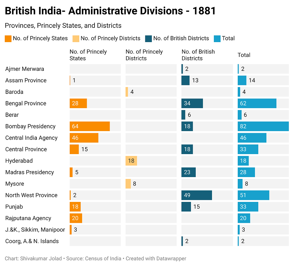
Between 1881 and 1911, there were some provincial and district restructuring. Parts of Bengal and Assam province merged to form East Bengal and Assam, with Lushai Hills (Mizoram) joining it. Central Provinces and Berar merge to form a single Central Provinces and Berar. North West provinces and Oudh become United Provinces and Oudh. Some districts of Central Provinces get merged with Bengal provinces, and Bengal Province- Orissa tributary states. However, the total number of districts in British India remained relatively stable, increasing slightly from 410 to 412. During this period, British districts increased marginally from 179 to 181, while large princely states grew from 202 to 203, and princely districts reduced from 29 to 28, indicating minor administrative adjustments. This era was marked by significant political developments in British India. The Partition of Bengal in 1905 was a major event, widely perceived as an attempt to divide the nationalist movement along communal lines. It was annulled in December 1911, and the decision was made to shift the capital of British India from Calcutta to Delhi.

Summary of changes between 1901 to 1911
Major Provincial Reorganization (Partition of Bengal):
Bengal Province was partitioned in 1905, creating Eastern Bengal and Assam Province. This new province included Assam and a considerable part of old Bengal, transferring Dinajpur and Jalpaiguri British districts and Hill Tippera Princely state from Bengal, and Maida district from Bihar. It had 15 British districts and 2 Princely states.
Bengal Province lost these areas but gained Sambalpur British district and five Princely states (Kalahandi, Patna, Sonpur, Rairakhol, Bamra) from Central Province. Angul & Khondmals renamed Angul.
Central Province gained five feudatory states (Chang Bhakar, Korea, Sirguja, Udaipur, Jashpur) from Bengal's Chota Nagpore division.
Berar's Permanent Lease and Merger: Berar, leased from Nizam of Hyderabad since 1853, was permanently ceded to the Central Province in 1903, becoming Central Province and Berar. Its six districts were reorganized into four (Ellichpur merged with Amraoti, new Yeotmal from Wun and Basim). A part of Yeotmal transferred to Akola. Central Province and Berar also gained Drug British district from Raipur and Bilaspur.
Sikkim: Control of Sikkim was taken over by the Government of India in 1906.
Hyderabad: Princely district Lingsugur was abolished; its talukas transferred to Raichur and Gulbarga. Oosmanabad (Naldrug) renamed Osmanabad.
Bombay Presidency: Khandesh British district bifurcated into Khandesh East and Khandesh West. Princely state Kankrej (Thara) renamed Kankrej.
Madras Presidency: 22 British districts reconstituted into 25. Guntur district emerged from Kistna (Krishna), Godavary (Godavari), and Nellore. Madura divided into Madura and Ramnad. North Arcot re-emerged as North Arcot and Chittoor.
Rajputana Agency: Lawa (estate), Kushalgarh (estate), and Shahpura (Chiefship) were renamed Lawa, Kushalgarh, and Shahpura.
North West Province: Renamed United Province of Agra and Oudh.

1911-1921 - Provincial and District changes
Assam Province: Restored to Chief Commissionership. Balipara Frontier Tract and Sadiya Frontier Tract created from Lakhimpur and Darrang districts. Lost Maida, Dinajpur, and Jalpaiguri districts to Bengal. Hill Tippera Princely state was renamed Tripura and added to Bengal's jurisdiction. Singhpos tribes indicated in Assam.
Delhi: Declared a new province in 1921, affecting Gurgaon and Rohtak districts.
Gwalior: Excision of Gwalior state from Central India Agency; it became an independent Princely state and was reorganized into eleven Princely districts.
Bihar and Orissa Province: Bihar, Chota Nagpore, and Orissa Tributary State formed a separate province in April 1912.
Bombay Presidency: Bombay Suburban district created from Thana. Mewas Princely state lost status, The Dangs renamed Dangs.
Madras Presidency: Agency tract carved out from Vizagapatam, Godavari, and Ganjam British districts.
United Province of Agra and Oudh: A new Princely state, Benares, came into existence. A large part (864 sq miles) from Mirzapur district was added to this new Princely state.
Rajputana Agency: A new Princely state, Abu, was formed. Lawa, Kushalgarh, and Shahpura renamed Lawa (estate), Kushalgarh (chiefship), and Shahpura (chiefship).
Ajmer Merwara: Ajmer and Merwara British districts amalgamated into one, Ajmer-Merwara.
Baroda Province: A new Princely state of Okhamandal was formed.
1921 to 1931 - Provincial and District changes
Minor Internal Changes: Administrative divisions were almost similar to 1921, with a few minor changes in internal boundaries of provinces. Foreign territories remained unchanged.
Assam Province: Changes in district boundaries between Kamrup, Darrang, Cachar, Sylhet, and Lushai Hills.
Bihar and Orissa Province: Minor adjustment in inter-provincial boundaries. Transfer of 13 inhabited villages from Santhal Parganas (Bihar and Orissa) to Maida (Bengal). Boundary between Princely state Saraikela and British district Singhbhum altered.
Bombay Presidency: Bifurcated, 31 of 62 Princely states remained, rest lost to the newly formed Western India State Agency. Baria Princely state renamed Devgad Baria. Boundary between Kolhapur and Miraj Princely states changed.
Madras Presidency: Provincial boundaries unchanged. Agency British district (tribal areas of northern districts) annulled and added to Godavari East, Vizagapatam, and Ganjam British districts. Godavari British district bifurcated into Godavari West and Godavari East.
Punjab Province: Nahan renamed Sirmoor.
Rajputana Agency: Shahpura (chiefship) Princely state renamed Shahpura.
Baroda: Kadi Princely state renamed Mehsana.

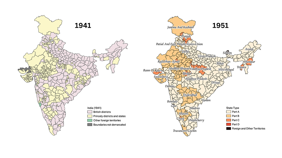
1931 to 1941 - Provincial and District changes
Bombay Presidency: Designated as Bombay under the Government of India Act (1935). Broach and Panch Mahals British districts formed a new district. Khandesh West, Khandesh East, and Princely state Devgad Baria were renamed West Khandesh, East Khandesh, and Baria districts. Mahikantha Agency Princely state and parts of Ahmedabad British district transferred to Western India State Agency.
Western India State Agency: Mahikantha (Mahikanta) Agency bifurcated into three independent Princely states: Idar, Vijayanagar, and Sabarkantha. Palanpur Princely state lost to Rajputana Agency. Kankarej Princely state was renamed Thara.
Rajputana Agency: Palanpur area (gained from Western India State Agency) bifurcated to form Palanpur and Danta Princely states.
Orissa Province: Separated from old Bihar and Orissa and constituted as a separate province in April 1936, due to the movement for amalgamation of Oriya speaking tracts. Vizagapatam British district (Madras) bifurcated to form Koraput district and added to Orissa. Ganjam British district (Madras) also gained by Orissa. Included British districts of Balasore, Cuttack, Puri, and Sambalpur. Angul British district lost separate identity and was included in Cuttack.
Central Province: British districts Narsinghpur, Damoh, and Seoni amalgamated with Hoshangabad, Saugor, and Chhindwara, respectively.
Gwalior: Princely districts Tonwarghar, Narwar, Isagarh, and Amjhera renamed Morena, Shivpuri, Goona, and Sardarpur respectively.
Hyderabad: No significant change except creation of Baghat Princely district.
Mysore: New Princely district Mandya created from portions of Mysore Princely district.
Burma Province: Ceased to be part of India.
Naga Tribes: Change in territorial boundary of area demarcated for Naga Tribes.
Summary provincial changes 1872-1941
British India in 1941
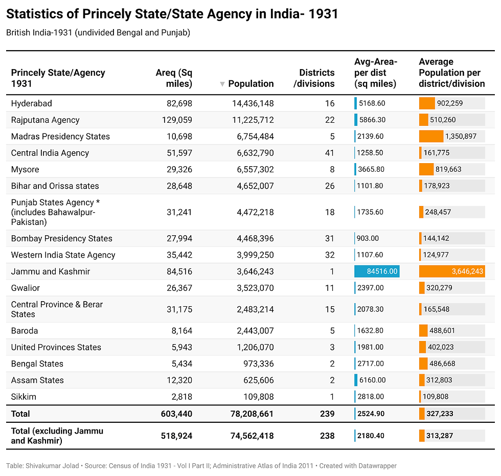
By 1941, India under British administration consisted of British provinces and its districts and numerous princely estates and jagirs. Together they formed 424 larger administrative units - 202 princely states, 42 princely districts, and 180 British districts. Bombay Province (which included current Gujarat, Western Maharashtra and Northern Karnataka), United Provinces (current UP and Uttarakhand) had 51 districts each. (Singh et al, 2004)


References
Chanda, A. (1967). Indian Administration (2nd ed.). George Allen & Unwin.
Government of India. (2011). Indian Administrative Atlas 1872-2011: Census of India 2011. Registrar General of India and Census Commissioner.
Singh, R. P., Banthia, J. K., & Commissioner I. O. of R.G. & C. (2004). India Administrative Atlas, 1872-2001: A Historical Perspective Of Evolution Of Districts And States In India. Registrar General of India.

Comments