
8 | Disparity and Heterogeneity in Indian Districts
- Jul 28, 2025
- 3 min read
Updated: Aug 20, 2025
Indian districts exhibit significant heterogeneity across parameters such as population, area, and population density, with disparities evident both across and within states. From the table below it is evident that districts across the country differ widely in terms of their demographic characteristics. Analysis of the Census 2011 figure presents stark disparity in Demographic and geographical inequality districts.
Inequality in Population, Area, and Density
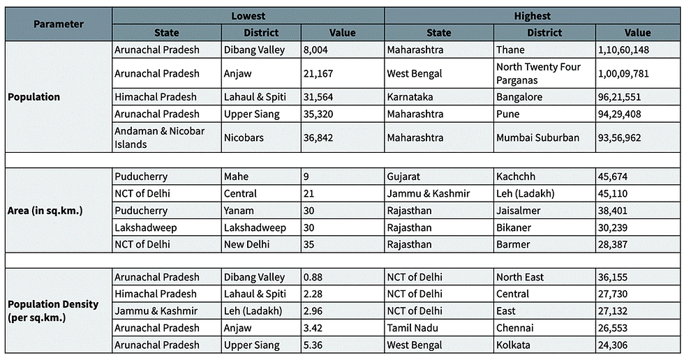
Population: On one hand, there are Thane (now split into Thane and Palghar) and North Twenty Four Parganas (bordering Kolkata) districts, with more than 1 crore population, while on the other hand there is Dibang Valley, which has the lowest population of all districts in the country, which is merely 8,000 (as per 2011 Census data).

Area: Even with regard to area, districts are extremely heterogeneous. As per 2011 data, only six districts out of 640 total districts had an area more than 20000 sq. km. Kachchh district had the highest area, 45,674 sq. km, followed by Leh district. Contrasting the largest district with the smallest district in the country - Mahe (Puducherry), with just 9.85 sq. km of area gives a clear picture of the massive disparity in the area of districts in the country.
Population Density: As per 2011 Census data, North East district in NCT of Delhi has the highest population density, followed by the Central and East districts in the state. On the other hand, India also has districts which have a population density that is less than 10 per sq. km, specifically Dibang Valley (0.88 per sq. km.) and Lahaul and Spiti (2.28 per sq. km.) in the states of Arunachal Pradesh and Himachal Pradesh respectively. The huge disparity suggests that even population density is not uniformly distributed within the country’s districts. Disparities within states reveal considerable heterogeneity. States like West Bengal have districts with densely populated urban centers (e.g., Kolkata) alongside less densely populated rural areas. Arunachal Pradesh, on the other hand, has districts with uniformly low population densities due to its challenging terrain and sparse settlement patterns.
From the analysis of districts in India based on their area, population, and population density, it is evident that there is significant heterogeneity among them. While differences between districts from different states are expected due to geographical variations, it is also important to consider variations within states. What is surprising is that even within states, which are supposed to be relatively homogeneous, districts also show enormous variations. State-wise comparison of district population illustrates that the average population is highest in the state of West Bengal and lowest in Arunachal Pradesh. Even within a state, whose districts have similar cultural and historical roots, and geographical features, huge disparity in population exists.
The heterogeneity of districts in India underscores the complexities of governance in such a diverse country. While district creation is often justified on grounds of administrative efficiency, the lack of standardized policies and clear criteria suggests a need for reform. Addressing disparities in population, area, and density, along with minimizing political interference, could lead to more effective and equitable district governance.
References
Government of India. (2011). Indian Administrative Atlas 1872-2011: Census of India 2011. Registrar General of India and Census Commissioner.
Office of the Registrar General & Census Commissioner, India. (2011). Census of India 2011.
Jolad, S., & Kalra, M. (2024, September 26). Why Indian Districts Are Not Equal. Dataviz. https://www.indiaspend.com/data-viz/why-indian-districts-are-not-equal-925439

Comments